In the fascinating world of weather, there is a dance happening between the Azores High and Icelandic Low that greatly impacts the amount of warm water the Atlantic carries to the Arctic along the Norwegian coast. However, this delicate rhythm can be disrupted for extended periods of time.
Finally, experts from the Alfred Wegener Institute have uncovered the reason behind this disruption. Unusual atmospheric pressure conditions over the North Atlantic divert low-pressure areas from their usual path, throwing off the connection between the Azores High, Icelandic Low, and the winds along the Norwegian coast. This discovery is a significant step towards improving climate models.
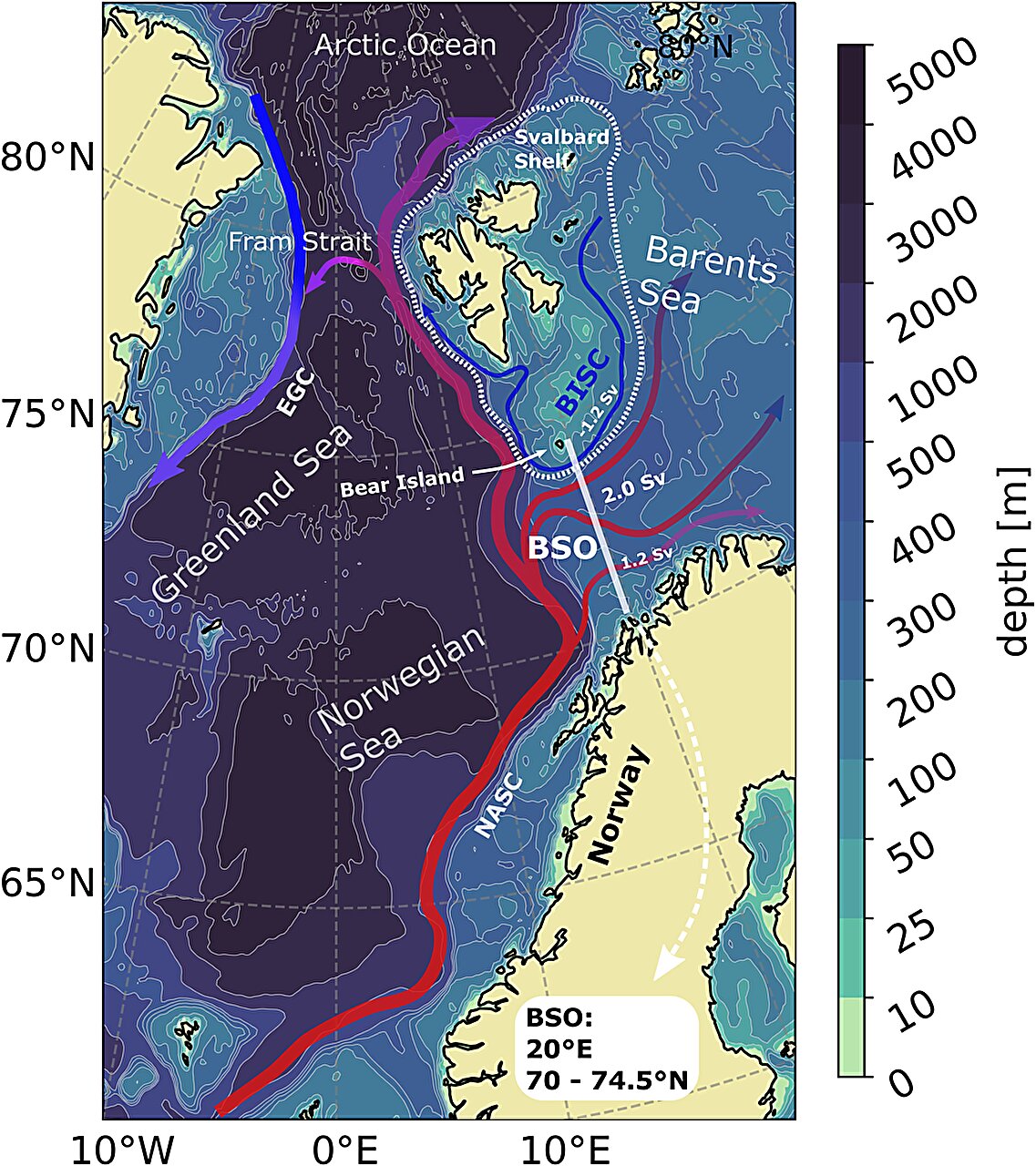
During winter, the Norwegian coast is typically subjected to harsh conditions. The wind blows relentlessly from the southwest for days or even weeks. Low-pressure areas travel along the coast, bringing rain and snow, while the winds they generate determine the amount of warm water the Atlantic transports to the Barents Sea and the Arctic. However, this flow of warm water can vary, and climate researchers are eager to understand these fluctuations to enhance their computer models’ ability to predict changes in Arctic sea-ice extent over the next few decades.
The challenge lies in comprehending the complex air and ocean currents off the coast of Norway and in the Barents Sea. Understanding the cause of these fluctuations is crucial for further advancements in climate models.
A team led by oceanographer Finn Heukamp from the Alfred Wegener Institute has recently published a study shedding light on ocean currents along the Norwegian coast and into the Barents Sea. They focused on the atmospheric pressure difference between the Azores High and Icelandic Low, also known as the North Atlantic Oscillation (NAO), which shapes the currents off Norway. Their main question was why there are sometimes extreme deviations from the typical interplay between the NAO and weather conditions.
Typically, the intensity of the winds and ocean currents is primarily determined by the atmospheric pressure difference in the NAO. A stronger NAO creates powerful air currents that drive low-pressure areas across the North Atlantic and past Norway towards the north. When the atmospheric pressure difference weakens, both the winds and low-pressure areas lose momentum. Consequently, the NAO, the track of low-pressure areas, and the intensity of ocean currents off the coast of Norway are closely intertwined.
However, a decoupling of the NAO and ocean currents was observed in the Barents Sea as far back as the late 1990s. “This unusual decoupling frequently occurred during the winter between 1995 and 2005,” says Heukamp. “But the cause of these changes remained unclear.”
Thanks to a mathematical ocean model that simulates the Arctic Ocean at a high resolution, the experts now have an answer. It turns out that the phenomenon is caused by an unusual shift in the track of low-pressure areas. Heukamp has discovered that the stream of low-pressure areas passing by Norway, moving from the southwest to the north, is sometimes disrupted by powerful, nearly stationary high-pressure areas known as blocking highs. These blocking highs push the fast-moving low-pressure areas off their usual path, temporarily decoupling the NAO and the northward flow of warm water.
“At the moment, we cannot determine how often this situation occurs, such as whether it repeats every few decades, because the observational data we use to compare with our ocean model only covers approximately 40 years,” explains Heukamp. Nevertheless, these findings are crucial for climate modeling. “Global climate models operate on a broad scale,” says the researcher. “With our latest high-resolution analysis for the North Atlantic and the Arctic, we have added an important detail to improve climate modeling accuracy for the Arctic.”
These findings also highlight the need to consider the NAO, low-pressure areas over the Atlantic, and ocean currents together in the future. As both the transport of warm water and the track of lows over the Atlantic impact weather in the middle latitudes, these results are also significant for predicting the future climate and weather in Central Europe.